
This Insight examines the unresolved Sir Creek dispute between Pakistan and India. The focus remains on legal ambiguity and competing territorial and maritime claims, with an understanding of their implications for maritime delimitation in the Arabian Sea. It also encompasses maritime security and resource governance in light of already settled principles of International and Maritime Laws.
The Sir Creek is a 96-kilometre-long tidal estuary located in the Rann of Kutch. It forms part of the boundary between Pakistan’s Sindh province and India’s Gujarat state. Sir Creek once acted as a natural boundary marker in colonial revenue administration. The Sir Creek dispute had erupted between Kutch and Sindh in 1908, which was then known as ‘Ban Ganga’.
The dispute lies in differing interpretations of colonial-era administrative instruments. The most significant is the Resolution 1192 of the Government of Bombay, 1914.
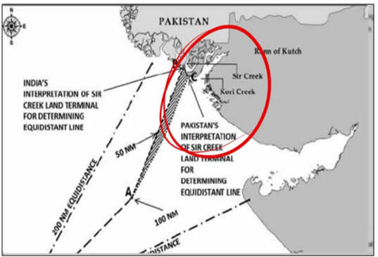
The Sir Creek dispute centres on whether the border between Sindh and Gujarat lies within the estuary or on its eastern bank. If the border is within the estuary itself, then both India and Pakistan will have ownership of the waters of the Sir Creek. If the border is determined to be the eastern bank of the Sir Creek estuary, Pakistan has full ownership of the creek, and India has no access to its waters.
The resolution explicitly demarcated the Sindh–Kutch boundary along the eastern bank of Sir Creek. To cement the settlement, the Surveyor General’s Map B-44 depicted the “Green Line” as the final, binding border. Sir Creek was therefore not left ambiguous; it was legally and administratively settled prior to the independence of Pakistan and India.
The 1968 Rann of Kutch Tribunal, established under the initiative of British Prime Minister Harold Wilson, was tasked with resolving the broader Kutch boundary dispute and did not address Sir Creek, which had already been settled by the 1914 Resolution. The tribunal process concluded without any determination on Sir Creek, and its non-consideration does not negate the legality or validity of the pre-partition boundary settlement.
The tribunal process concluded without any determination on Sir Creek, and its non-consideration does not negate the legality or validity of the pre-partition boundary settlement. The central legal ambiguity that persists today concerns the precise location of the land terminus point (LTP) at Sir Creek, an issue that directly affects the determination of maritime baselines. Despite multiple rounds of bilateral negotiations and a joint hydrographic survey, Pakistan and India were unable to reach an agreement between 2007 and 2009 on whether the boundary follows the eastern bank of the creek or its mid-channel.
Pakistan’s stance on Sir Creek is anchored in the historic 1914 resolution, which placed the creek entirely within Sindh’s administrative jurisdiction according to the Government of Bombay’s survey maps. Pakistan maintains that the international boundary runs along the eastern bank of Sir Creek, a position supported by two principal legal grounds: first, the historical administrative settlement under the 1914 resolution and its supporting survey maps; and second, the requirement under UNCLOS that maritime boundaries must emanate from an agreed land boundary. The doctrine of uti possidetis juris underpins Pakistan’s argument, as it preserves pre-independence administrative boundaries as international borders. Accordingly, the prior determination of the land terminus point is legally indispensable for establishing maritime limits.
India argues that the boundary in Sir Creek should follow the thalweg (mid-channel) of the creek, claiming that the creek was treated as a navigable waterway for boundary purposes. India also maintains that the 1914 Resolution was merely administrative and not legally binding as a final boundary settlement. However, under international law, the principle of uti possidetis juris transforms colonial administrative boundaries into international borders at independence. As a general principle of decolonisation, it applies wherever colonial rule ends, which ultimately undermines India’s attempt to disregard the pre-partition boundary arrangement.
For Pakistan and India, Sir Creek is very important; in the north-eastern Arabian Sea, the dispute affects thousands of square kilometres (approximately 8,000 sq km) of potential maritime entitlement, known as the exclusive economic zone (EEZ). This uncertainty constrains not only offshore hydrocarbon exploration and fisheries management. It is also affecting maritime law enforcement and the effective implementation of national and international laws.
India’s militarisation of the Sir Creek area is concerning. Coercive concentration of BSF, Coast Guard, and Navy units, along with elements of the Special Operations Division (AFSOD), is deployed in proximity. By contrast, Pakistan’s military presence in the area is purely defensive. The Pakistan Navy maintains the 301 Creek Brigade, a specialised formation of Pakistan Navy Marines. The Brigade is explicitly tasked with defending territorial integrity. It has no offensive posture and exists solely to safeguard Pakistan’s sovereignty.
In this regard, a durable resolution of the Sir Creek dispute requires the clear demarcation of the boundary. The lack of a settled boundary has led to practical challenges, including the growing impact of sea-level rise and climate change, which further complicates boundary determination. Ongoing uncertainty also contributes to repeated operational and enforcement issues.
While interim cooperative arrangements are grounded in the principle of voisinage, they offer a pragmatic means to de-escalate immediate tensions and manage shared resources. Measures such as joint resource management or coordinated patrols can help mitigate humanitarian concerns and foster practical cooperation. However, these arrangements cannot substitute for a definitive legal resolution and do not resolve the underlying legal ambiguities at the heart of the dispute.
A durable and sustainable solution requires a precise and unambiguous boundary demarcation, meticulously aligned with established principles of international law, including the UNCLOS and the doctrine of uti possidetis juris. This underscores the necessity of interim confidence-building measures alongside a long-term legal settlement.